Drive Picton to Haast in 5 days: Lake Rotoiti in Nelson Lakes, the Buller Gorge Swingbridge, the seals at Cape Foulwind, the Pancake Rocks at Punakaiki, Hokitika Gorge, Franz Josef and Lake Matheson, then the wild coast to Haast. It is about 710 km, with no day over three hours of driving by our routing estimates. Fuel up in Westport or Greymouth (there is none at Punakaiki) and again at Haast.
On this page
Key facts
- Start and finish
- Picton to Haast (one way)
- Total driving
- About 710 km, about 9 h 45 min without stops (estimate)
- Longest day
- Day 2, St Arnaud to Westport and Cape Foulwind, about 210 km
- Paid car parks
- Punakaiki and Franz Josef Glacier: $2.50 per half hour or $20 a day (DOC)
- Fuel gap
- No petrol at Punakaiki; fill up in Westport or Greymouth
- Book ahead
- Ferry, Kerr Bay Campsite, summer beds, any glacier flight
- Checked
- As at November 2026
The West Coast is the South Island at its wildest: a narrow strip of rainforest, river gorges and surf-battered coast between the Southern Alps and the Tasman Sea, with more seals than traffic lights. This five-day route starts at the Picton ferry terminal and follows the coast south to Haast, where the road turns inland over the Haast Pass.
It is written for first-timers. Every day has a plan, the places explained, where to sleep and the practical bits: fuel, food, toilets and what to book. Prices and opening hours were checked on official sites as at November 2026. Drive times are routing estimates without stops, so add time for photos, roadworks and the odd one-lane bridge queue.
Route overview
- Start and finish
- Picton to Haast
- Days
- 5 days
- Total driving
- About 710 km
- Longest day
- Day 2, St Arnaud to Westport and Cape Foulwind, about 210 km
- Best time
- October to April
The route runs one way from Picton to Haast. It cuts inland from Marlborough to the lakes of Nelson Lakes National Park, follows the Buller River down to the coast at Westport, then runs south on State Highway 6 for the rest of the trip: Punakaiki, Greymouth, Hokitika, the glaciers and the empty coast to Haast.
It links neatly with other routes. From Haast you can continue over the pass to Wānaka and Queenstown, or turn it into a loop with our 14-day South Island road trip, which drives this coast from Arthur’s Pass southwards.
Day-by-day itinerary
Day 1: Picton to St Arnaud and Lake Rotoiti
Picton→St Arnaudvia State Highway 1 and State Highway 63
- DistanceAbout 132 km
- Drive timeAbout 1 h 50 min (estimate)
- OvernightSt Arnaud
Roll off the Cook Strait ferry, cross the Marlborough vineyards and spend the first night beside a clear alpine lake in Nelson Lakes National Park.
Picton is where the ferries from Wellington land, at the head of Queen Charlotte Sound. If you are crossing with a vehicle, our Interislander vs Bluebridge comparison explains the two operators. From Picton the road runs south to Blenheim, the main town of the Marlborough wine region, then west up the Wairau Valley on State Highway 63.
Tonight's base is St Arnaud, a tiny village on the shore of Lake Rotoiti in Nelson Lakes National Park. DOC puts it about 1 hour 30 minutes by car from Nelson or Blenheim. Our routing estimate from Picton is about 132 km and 1 hour 50 minutes without stops.
This is a gentle first day, which is what you want after a ferry crossing. The roads are sealed and easy. Arrive with time for a lakeside walk, because the beech forest around Kerr Bay is the first taste of the South Island's mountains.
How the day runs
- Morning
Arrive in Picton on the ferry, or collect your vehicle there. Buy groceries before you leave town.
- Midday
Lunch in Blenheim or at a winery on the way out of the Wairau Valley.
- Afternoon2.30 pm
Arrive in St Arnaud. Call into the Nelson Lakes Visitor Centre before it closes at 4 pm, then walk to Kerr Bay.
- Evening
Sunset at Kerr Bay and an early night.
Stops and highlights3
Nelson Lakes National Park Visitor Centre. The DOC visitor centre in St Arnaud, open 9 am to 4 pm. Ask about walks, weather and track conditions here (DOC).
- Cost: Free
Kerr Bay and the Bellbird Walk. Kerr Bay is the main lakefront area in St Arnaud, with views up Lake Rotoiti. The Bellbird Walk is a 5 minute loop through beech forest full of birdsong, and the Honeydew Walk is a slightly longer forest loop from the same area (DOC).
- Time: 5 to 45 min
- Cost: Free
Brunner Peninsula Nature Walk. A lakeside walk out along the peninsula from Kerr Bay, through forest with views across the water (DOC).
- Time: Up to 1 h 30 min
- Cost: Free
Where to stay tonightSt Arnaud
- DOC campsite: Kerr Bay Campsite is 500 m from the village shop, with token hot showers, a laundry and a dump station. From 19 October to 30 April non-powered sites are $27 per adult and powered sites $30. Bookings are required all year, no spaces are kept for walk-ins, and vehicles must be under 7 m. No pets or fires (DOC).
- Freedom camping: Self-contained only, and only where DOC or the council allows it. Read our freedom camping guide first.
Tip: Book the earliest ferry you can. A morning arrival in Picton turns today from a rush into a lazy lakeside afternoon.
Practical infoFuel, food, toilets, bookings, costs
- Fuel
- Fill up in Picton or Blenheim before you head inland.
- Food and coffee
- St Arnaud has a small village shop. Bring most of your food from Picton or Blenheim.
- Toilets and dump stations
- At the visitor centre and Kerr Bay.
- Book ahead
- Your ferry crossing and Kerr Bay Campsite, which must be booked (DOC).
- Best time of day
- Arrive before 4 pm to catch the visitor centre.
- Watch out for
- There is no ATM in St Arnaud (DOC), so carry a card or some cash. Sandflies love the lakeshore at dusk.
- What today costs
- Ferry and fuel, plus Kerr Bay Campsite from $27 per adult (DOC, as at November 2026). The walks are free.
Got extra time?
- St Arnaud Range Track: a steep climb above the bushline for big lake views, for fit walkers with a full day (DOC).
Skip if
Arriving on a late ferry? Stay in Picton or Blenheim and drive straight through to Westport tomorrow, stopping at Lake Rotoiti for lunch.
Day 2: St Arnaud to Westport via the Buller Gorge and Cape Foulwind
St Arnaud→Westportvia State Highway 63, State Highway 6 and the Buller Gorge
- DistanceAbout 176 km, plus 35 km to Cape Foulwind and back
- Drive timeAbout 2 h 55 min, plus 45 min (estimate)
- OvernightWestport
Follow the Buller River through a forested gorge, wobble across New Zealand's longest swing bridge and finish watching fur seals at Cape Foulwind.
Today you drop from the lakes to the sea along the Buller River, which carves a long, steep gorge through the ranges to the coast at Westport. The road is sealed but winding in the gorge, with narrow sections and one-lane bridges, so take it steady and pull over to let faster traffic pass.
The highlight is the Buller Gorge Swingbridge, a 110 m long bridge hung 19 m above the river, which its operator describes as New Zealand's longest swing bridge. After that the gorge opens out to farmland and the small town of Westport, at the mouth of the river.
Our routing estimate from St Arnaud to Westport via the swing bridge is about 176 km and 2 hours 55 minutes without stops. Save energy for the evening: Cape Foulwind and its seal colony are 15 minutes' drive from Westport (DOC).
How the day runs
- Morning9 am
Leave St Arnaud and drive to Murchison for coffee.
- Midday11 am
Buller Gorge Swingbridge: cross the bridge and walk to Ariki Falls, or try the Comet Line.
- Afternoon2.30 pm
Continue down the gorge to Westport and check in.
- Evening5 pm
Drive to Tauranga Bay for the seal colony and, if you have energy, the walkway to the lighthouse.
Stops and highlights2
Buller Gorge Swingbridge. Cross the 110 m bridge, then follow the Forest Gold Walk (about 30 minutes) or the walk to Ariki Falls (about 1 hour return) on the far side. The park also runs the Comet Line, a seated flying fox back across the gorge, and gold panning (Buller Gorge Swingbridge).
- Time: Allow 1 to 2 h
- Cost: Bridge entry $12.50 adult, $5 child (14 and under); Comet Line $40 adult. No booking needed for the bridge.
Cape Foulwind Walkway and the seal colony. From the Tauranga Bay car park it is a 1 km return walk (30 min) to the seal colony viewpoint, suitable for wheelchairs. Seals are there all year and pups appear in summer. The full walkway to the lighthouse is 5.8 km return (2 h). Watch the seals from the platform only (DOC).
- Time: 30 min to 2 h
- Cost: Free
- Parking: Free at Tauranga Bay
Where to stay tonightWestport
- Holiday park: Westport Holiday Park says it is the closest holiday park to the town centre, a 2 minute drive away, with motels, chalets, tent sites and powered sites.
- Motels: Westport has motels and hotels in town. Book ahead in summer.
- Freedom camping: Self-contained only, where the council allows it. See our freedom camping guide.
Tip: Do the short seal colony walk first, then decide on the lighthouse leg. Families with small children often find the 30 minute version is plenty.
Practical infoFuel, food, toilets, bookings, costs
- Fuel
- Murchison and Westport.
- Food and coffee
- Murchison for morning tea, then Westport for groceries and dinner.
- Toilets and dump stations
- At the swing bridge park and at Tauranga Bay (DOC). There is no drinking water at Cape Foulwind.
- Book ahead
- Nothing essential today. Book Westport beds ahead in December and January.
- Best time of day
- Cape Foulwind in the late afternoon or evening. West Coast Tourism says October to March is the best time to see the seals.
- Phone coverage
- Coverage is patchy at Cape Foulwind (DOC) and drops in parts of the gorge.
- Watch out for
- Stay on the walkway at Cape Foulwind: the cliffs are high and unfenced in places. DOC warns that wasps may be present in summer. Never approach seals on beaches.
- What today costs
- Swing bridge entry $12.50 adult (prices from the operator's site, as at November 2026). Cape Foulwind is free.
Got extra time?
- Supaman: the swing bridge park's tandem flying fox ride, $70 (Buller Gorge Swingbridge).
- Gold panning: $12.50 per adult on top of bridge entry.
Skip if
Afraid of heights? Skip the swing bridge and spend longer at Cape Foulwind, which has no bridges at all.
Day 3: Punakaiki Pancake Rocks to Hokitika
Westport→Hokitikavia State Highway 6, the Great Coast Road
- DistanceAbout 140 km
- Drive timeAbout 2 h (estimate)
- OvernightHokitika
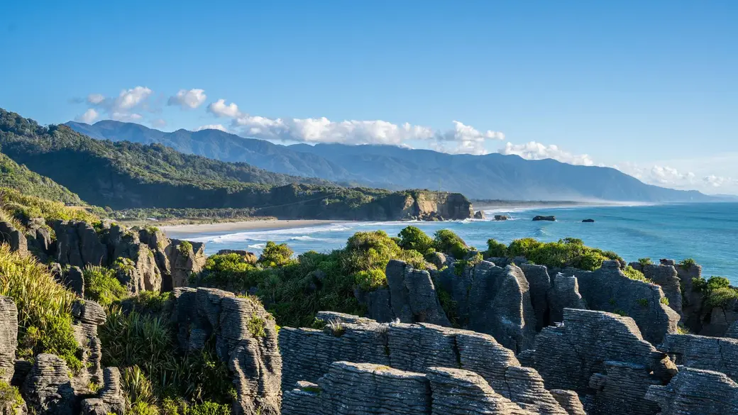
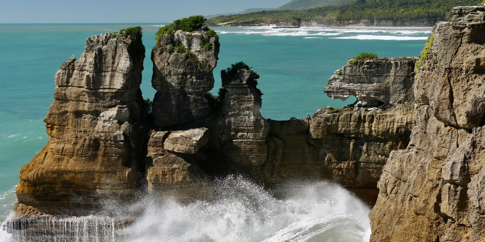
The Pancake Rocks at Punakaiki. Photo: Inspire Media Works via Pexels. Drive the coast road to the Pancake Rocks, find a hidden beach on the Truman Track and finish with a driftwood sunset and glow-worms in Hokitika.
The road south of Westport hugs the Tasman Sea between the Paparoa Range and the surf. It is one of the prettiest coastal drives in the country, with lookouts, surf beaches and sea stacks. The road is sealed and two lanes, with a few tight corners.
The big stop is Punakaiki, home of the Pancake Rocks, layers of limestone stacked like pancakes, with blowholes that roar and spout when the swell is up. They sit in Paparoa National Park, established in 1987 (DOC). Our routing estimate from Westport is about 56 km and 45 minutes.
After lunch you continue through Greymouth, the biggest town on the coast, to Hokitika, a small beach town known for driftwood, sunsets and pounamu (greenstone) carving. Punakaiki to Hokitika is about 84 km and 1 hour 15 minutes by our routing estimate.
How the day runs
- Morning9 am
Leave Westport and drive the coast to Punakaiki. Check the tide times: the blowholes are best around high tide.
- Midday10 am
Walk the Pancake Rocks loop, then the Truman Track. Picnic lunch with a sea view.
- Afternoon2 pm
Drive on through Greymouth to Hokitika and check in.
- Evening
Sunset on Hokitika beach, then the Glow Worm Dell once it is fully dark.
Stops and highlights4
Pancake Rocks and Blowholes Walk. A 1.1 km loop at Dolomite Point, opposite the visitor centre, that takes about 20 minutes. It is mostly wheelchair accessible with assistance. The blowholes perform best around high tide with a south-westerly swell. Do not climb on the rocks, and drones are prohibited (DOC).
- Time: 20 min loop
- Cost: Free
- Parking: DOC paid car park: $2.50 per half hour or $20 a day, card only; free for the first 10 minutes from 1 September 2026
Truman Track. A 30 minute return walk through coastal forest to a platform above a wild beach and a waterfall that drops onto the sand. It is signposted off SH6, 3 km north of the Punakaiki visitor centre. If the car park is full, DOC asks you to use the gravel shoulder 600 m south, not the highway verge.
- Time: 30 min return
- Cost: Free
Hokitika beach. Driftwood sculptures, the famous driftwood sign and big Tasman Sea sunsets (West Coast Tourism).
- Cost: Free
Hokitika Glow Worm Dell. A 50 m track off SH6 at the northern entrance to town leads to a bank of glow-worms, visible only after dark (Hokitika i-SITE).
- Time: 5 min return
- Cost: Free
Where to stay tonightHokitika
- Stay at Punakaiki instead: Punakaiki Beach Camp has riverside cabins, cliff-view campsites and holiday houses close to the Pancake Rocks. Handy if you want sunset at the rocks and a short day tomorrow.
- Hokitika: Holiday parks, motels and beachfront hotels. Book ahead from December to February.
- Freedom camping: Self-contained only, where the council allows it. See our freedom camping guide.
Tip: Time Punakaiki for high tide if you can. With a big south-westerly swell the blowholes send spray right over the viewing platforms.
Practical infoFuel, food, toilets, bookings, costs
- Fuel
- There is no petrol in Punakaiki (DOC). Fill up in Westport, or in Greymouth on the way to Hokitika.
- Food and coffee
- Services at Punakaiki are limited. Stock up in Westport, or shop in Greymouth or Hokitika.
- Toilets and dump stations
- At the Punakaiki visitor centre area.
- Book ahead
- Hokitika beds in summer. Nothing else needs booking.
- Best time of day
- The blowholes around high tide (DOC). Hokitika beach at sunset, and the Glow Worm Dell after dark.
- Watch out for
- The beach at the end of the Truman Track is dangerous. DOC warns of serious hazards there, so admire it from the platform and do not swim. Stay behind the barriers at the Pancake Rocks.
- What today costs
- Punakaiki parking up to $20 a day (DOC, as at November 2026). Everything else today is free.
Got extra time?
- West Coast Treetop Walk: an elevated walk through the rainforest canopy near Lake Mahinapua, just south of Hokitika (West Coast Tourism).
Skip if
If the sea is flat at low tide, skip the wait for the blowholes and spend longer on the Truman Track.
Day 4: Hokitika Gorge and on to Franz Josef
Hokitika→Franz Josef/Waiauvia State Highway 6
- DistanceAbout 200 km
- Drive timeAbout 2 h 45 min (estimate)
- OvernightFranz Josef/Waiau
A turquoise river gorge in the morning, then south down the coast road into glacier country and a first walk towards the ice.
The West Coast is a long, thin strip of land squeezed between the Southern Alps and the Tasman Sea, and it is wet. That rain is why the forest is so lush and the rivers so blue on a dry day.
This morning you drive inland through dairy farms to Hokitika Gorge, where the river runs milky turquoise between granite walls. Our routing estimate is about 69 km and 1 hour there and back. Then it is south on SH6 to Franz Josef/Waiau, a small glacier town about 134 km and 1 hour 45 minutes away.
SH6 is sealed and mostly two lanes, with long gaps between settlements and plenty of one-lane bridges. Signs at each bridge show who gives way.
How the day runs
- Morning8.30 am
Drive to Hokitika Gorge and walk the loop before the car park fills.
- Midday
Back in Hokitika for lunch, fuel and a look at the pounamu carvers.
- Afternoon2 pm
Head south on SH6 to Franz Josef/Waiau.
- Evening5 pm
Walk to Peters Pool or the glacier viewpoint while the light is soft.
Stops and highlights3
Hokitika Gorge. A viewing platform 150 m from the car park, a swing bridge 300 m further, and an optional loop over the upper suspension bridge, which at 90 m is one of the longest in New Zealand (DOC).
- Time: 1.6 km loop, about 1 h
- Cost: Free
- Parking: Free; very busy November to April
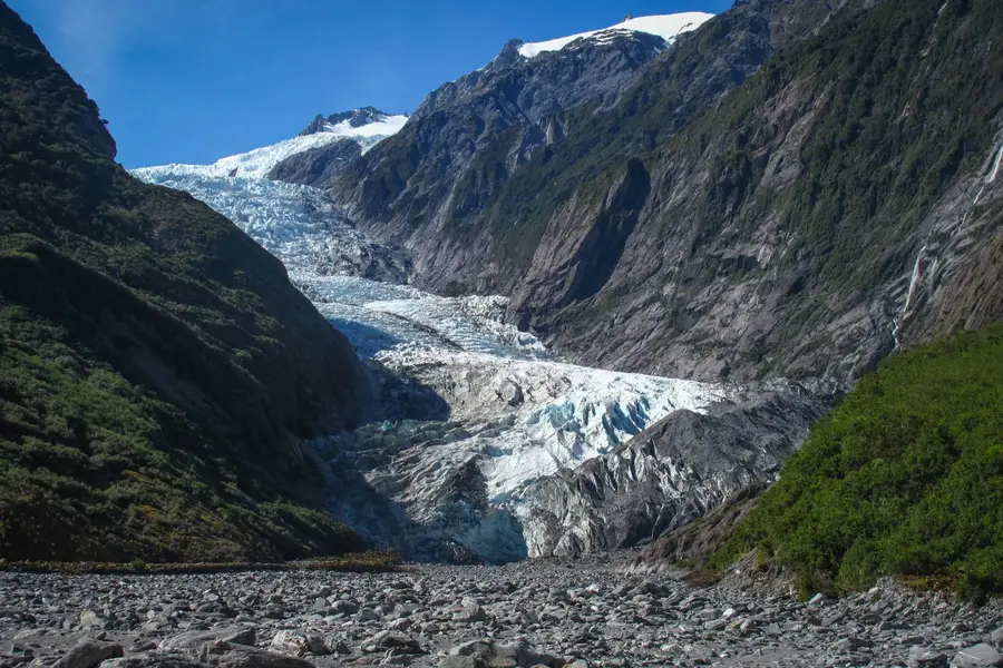
Franz Josef Glacier Walk. Follows the river valley to the viewpoint, about 4 km from town at the end of Glacier Access Road. Stay behind the barriers: river surges, rockfall and flash floods happen with little warning (DOC).
- Time: 1.7 km return, about 30 min
- Cost: Free
- Parking: DOC paid car park: $2.50 per half hour or $20 a day, card only
Peters Pool. A short walk from the same car park to a small pool that reflects the glacier valley and peaks on a calm day (DOC).
- Time: 1.1 km return, 25 min
- Cost: Free
Where to stay tonightFranz Josef/Waiau
- Franz Josef/Waiau: The town has holiday parks, motels, hostels and hotels, all within walking distance of the main street. Book ahead in summer.
- Freedom camping: Self-contained only, where the council allows it. See our freedom camping guide.
Tip: Walk the glacier valley in the late afternoon today. If tomorrow dawns clear, you can spend it at Lake Matheson instead of queuing at the glacier car park.
Do not swim in Hokitika Gorge. DOC warns the river is swift, cold and dangerous, and people have drowned here.
Practical infoFuel, food, toilets, bookings, costs
- Fuel
- Fill up in Hokitika. Franz Josef/Waiau has a service station (DOC).
- Food and coffee
- Hokitika has the most choice. Franz Josef/Waiau has grocery stores and places to eat (DOC).
- Toilets and dump stations
- Toilets at the Hokitika Gorge car park, but no drinking water (DOC).
- Book ahead
- A glacier heli-hike or scenic flight for tomorrow morning, if you want one.
- Best time of day
- A dry morning at the gorge. The water looks blue when it has not rained recently, and grey with glacial silt after heavy rain (DOC).
- Phone coverage
- No coverage beyond the gorge car park (DOC).
- Watch out for
- Sandflies (tiny biting flies) are fierce at the gorge, so bring repellent. Kea and weka are protected: do not feed them.
- What today costs
- The gorge is free. Glacier car park up to $20 a day (DOC, as at November 2026).
Skip if
Skip the gorge after heavy rain, when the water turns grey, and have a slow morning in Hokitika instead.
Day 5: Lake Matheson and the wild coast to Haast
Franz Josef/Waiau→Haastvia State Highway 6
- DistanceAbout 154 km
- Drive timeAbout 2 h 10 min (estimate)
- OvernightHaast
Mirror reflections of Aoraki/Mount Cook at dawn, a cliff-top lookout, a swamp forest boardwalk and the end of the West Coast road at Haast.
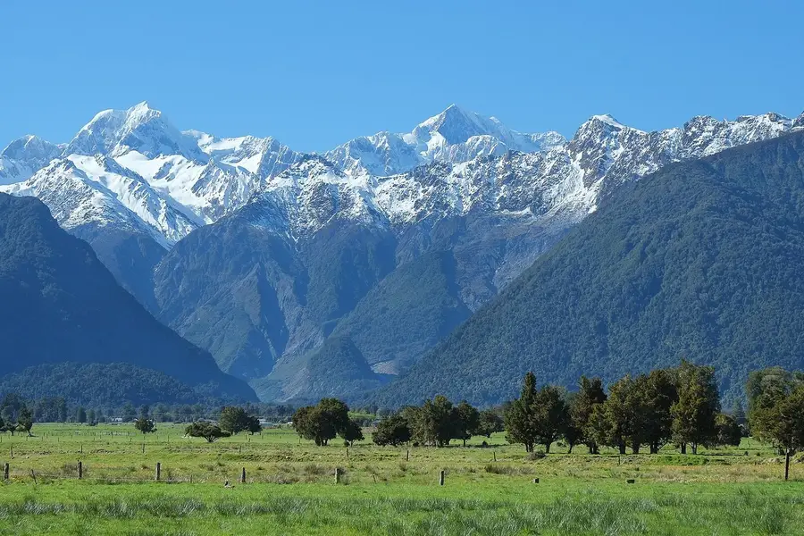
Lake Matheson/Te Ara Kairaumati, near Fox Glacier/Weheka, is famous for mirror reflections of Aoraki/Mount Cook and Mount Tasman in its dark water. Calm, clear mornings are best, so this is the day to set an alarm.
South of Fox Glacier the road runs through rainforest and along empty coastline. It is the most remote stretch of SH6 on this trip: settlements are few, and phone coverage comes and goes. Our routing estimate from Franz Josef to Haast via Lake Matheson, Knights Point and Ship Creek is about 154 km and 2 hours 10 minutes without stops.
Haast is a small settlement near the mouth of the Haast River and the start of the road over the Haast Pass to Wānaka. Tomorrow you can carry on over the pass. Our Queenstown to Franz Josef guide covers that road in detail, in the opposite direction.
How the day runs
- Morning7 am
Drive about 30 minutes to Lake Matheson for the reflections, then breakfast in Fox Glacier/Weheka, 5 minutes away (DOC).
- Midday
South down the coast: Knights Point lookout, then Ship Creek.
- Afternoon2 pm
Arrive in Haast. Call in at the Awarua/Haast Visitor Centre and fill up at the petrol station next door.
- Evening
Quiet night in Haast, or a short evening walk on the beach.
Stops and highlights4
Lake Matheson/Te Ara Kairaumati. The walk to Jetty Lookout suits wheelchairs, and the full circuit gives more viewpoints (DOC).
- Time: Jetty Lookout 2.4 km return (45 min), full circuit 4.4 km (1 h 30 min)
- Cost: Free
- Parking: Free; busy November to April
Knights Point. A prominent lookout with wide views along the coast (West Coast Tourism).
- Cost: Free
Ship Creek Tauparikākā. 20 km north of Haast. Two short walks from one car park: a boardwalk through ancient kahikatea swamp forest, and a trail to a dune lake and the beach. There is a viewing tower, toilets and picnic tables (DOC).
- Time: 800 m return (20 min) or 1 km loop (30 min)
- Cost: Free
Awarua/Haast Visitor Centre. The DOC visitor centre at Haast Junction, open 9 am to 4.30 pm, with toilets. Ask about the Haast Pass road and weather here.
- Cost: Free
Where to stay tonightHaast
- Haast: Haast has a holiday park, motels and lodges, but not many of them, so book ahead in summer.
- Freedom camping: Self-contained only, where the council or DOC allows it. See our freedom camping guide.
Tip: Lake Matheson is at its best before the wind gets up. Even 20 minutes of calm at dawn can give you the postcard reflection.
Practical infoFuel, food, toilets, bookings, costs
- Fuel
- Fox Glacier/Weheka, then Haast Junction, beside the visitor centre. Fill up in Haast before the Haast Pass.
- Food and coffee
- Fox Glacier for breakfast. Haast township, 3 km south of the junction, has a café, a tavern and a grocery store.
- Toilets and dump stations
- Lake Matheson car park, Ship Creek and the Haast visitor centre (DOC).
- Book ahead
- Haast beds in summer.
- Best time of day
- Lake Matheson at dawn or dusk on a fine, windless day (DOC).
- Phone coverage
- Unreliable at Lake Matheson and between towns. Download offline maps in Franz Josef.
- Watch out for
- Sandflies at Ship Creek and Lake Matheson. Heavy rain can cause slips on SH6, so check the NZTA Journey Planner before you set off.
- What today costs
- All of today's stops are free. Costs are fuel, food and your bed.
Got extra time?
- Monro Beach: near Lake Moeraki, 30 km north of Haast, where you might see tawaki (Fiordland crested penguins), most likely from August to November (DOC).
- Haast River Safari: jet boat trips in enclosed boats up the Haast River, which the operator says run daily, rain or shine.
Skip if
Low cloud at dawn? Skip Lake Matheson's sunrise, sleep in and walk the lake later on the way south.
Trip complete
That's the loop. You legend.
5 days and about 710 km of driving, finishing in Haast.
Full route in Google Maps (opens in a new tab)Back to the top of the itinerary
Drive times and distances
These are routing estimates without stops, rounded. Add at least 20 to 30 per cent for stops, campervans and slower traffic.
| Day | Leg | Distance | Drive (estimate) |
|---|---|---|---|
| 1 | Picton to St Arnaud via Blenheim | About 132 km | About 1 h 50 min |
| 2 | St Arnaud to Westport via the Buller Gorge Swingbridge | About 176 km | About 2 h 55 min |
| 2 | Westport to Cape Foulwind and back | About 35 km | About 45 min |
| 3 | Westport to Punakaiki | About 56 km | About 45 min |
| 3 | Punakaiki to Hokitika via Greymouth | About 84 km | About 1 h 15 min |
| 4 | Hokitika to Hokitika Gorge and back | About 69 km | About 1 h |
| 4 | Hokitika to Franz Josef/Waiau | About 134 km | About 1 h 45 min |
| 5 | Franz Josef to Haast via Lake Matheson and Ship Creek | About 154 km | About 2 h 10 min |
| Whole route, Picton to Haast | About 707 km | About 9 h 40 min |
Check the NZTA Journey Planner each morning. Heavy rain on the West Coast can close SH6 with slips or flooding, sometimes with little notice.
Must-see stops on the West Coast
If you only have time for a handful of stops, make it these:
| Stop | Why go | Time | Cost (as at November 2026) |
|---|---|---|---|
| Buller Gorge Swingbridge | 110 m swing bridge over the Buller River | 1 to 2 h | $12.50 adult |
| Cape Foulwind seal colony | Fur seals all year, pups in summer | 30 min | Free |
| Pancake Rocks, Punakaiki | Layered limestone and blowholes | 20 min | Free (parking up to $20 a day) |
| Truman Track | Wild beach and waterfall | 30 min | Free |
| Hokitika Gorge | Turquoise river and swing bridges | About 1 h | Free |
| Franz Josef Glacier Walk | Valley walk to the glacier viewpoint | About 30 min | Free (parking up to $20 a day) |
| Lake Matheson | Mirror reflections of Aoraki/Mount Cook | 45 min to 1 h 30 min | Free |
| Ship Creek | Swamp forest boardwalk and dune lake | 20 to 30 min | Free |
Insider tip: DOC’s paid car parks at Punakaiki and Franz Josef are card only and charge $2.50 per half hour, with the first 10 minutes free. A quick look at the Pancake Rocks costs you a few dollars, so no need to buy a full $20 day.
Where to stay
| Night | Base | Suggestions |
|---|---|---|
| 1 | St Arnaud | Kerr Bay Campsite (DOC, book ahead) |
| 2 | Westport | Westport Holiday Park, or a motel in town |
| 3 | Hokitika or Punakaiki | Punakaiki Beach Camp, or a holiday park or motel in Hokitika |
| 4 | Franz Josef/Waiau | Holiday parks, motels and hotels in town |
| 5 | Haast | A small choice of motels, lodges and a holiday park: book ahead |
West Coast towns are small and spread out, so do not count on rolling up to a vacancy in December or January. In a campervan, freedom camping is self-contained only and only where councils or DOC allow it; our freedom camping rules explain where and how.
Weather, sandflies and other West Coast realities
Rain is part of the deal. DOC says Westland Tai Poutini National Park can get up to five metres of rain a year. The upside is waterfalls everywhere and that famous green. The downside is that rivers can rise fast, flights get cancelled and roads occasionally close. Build slack into your plans, and keep a glacier flight on a morning when you can wait a day.
Sandflies are tiny, silent and relentless. They are worst at dusk by lakes, rivers and bush. Long sleeves and a good repellent help more than any amount of swatting.
Kea and weka are protected birds. Do not feed them, and keep food and shiny things out of reach.
Fuel and phone gaps. There is no petrol at Punakaiki (DOC), and coverage drops in the Buller Gorge, at Hokitika Gorge and much of South Westland. Fill up whenever you pass a station, and download offline maps.
Campervan or car
The West Coast is easy campervan country: sealed roads, holiday parks in every town and DOC campsites in the national parks. A car is fine too, and slightly quicker on the winding gorge roads. Either way, prices swing hugely with the season, and one-way hires can cost more than returns, so compare a few companies for your exact dates.
Variations
- Start in Nelson: swap day 1 for a night in Nelson and drive to Westport through Murchison, picking up the route at the Buller Gorge.
- Add Arthur’s Pass: from Greymouth, turn inland over Arthur’s Pass to Christchurch instead of continuing south.
- Slow down at the glaciers: add a second night in Franz Josef so a cancelled heli-hike can be rebooked.
- Keep going south: from Haast, drive over the Haast Pass to Wānaka and Queenstown, then on to Milford Sound.
FAQ
How many days do you need for the West Coast?
Is the West Coast road trip worth it?
What is the best time of year to drive the West Coast?
Where should I stay on the West Coast?
Can I drive from Franz Josef to Queenstown in one day?
Sources
Last checked 11 November 2026
- Kerr Bay Campsite · Department of Conservation
- Nelson Lakes National Park Visitor Centre · Department of Conservation
- Lake Rotoiti Kerr Bay walks · Department of Conservation
- St Arnaud Range Track · Department of Conservation
- Buller Gorge Swingbridge Adventure and Heritage Park · Buller Gorge Swingbridge
- Cape Foulwind Walkway · Department of Conservation
- Westport Holiday Park · Westport Holiday Park
See more sources (19)See fewer
- Punakaiki Pancake Rocks and Blowholes Walk · Department of Conservation
- Truman Track · Department of Conservation
- Paparoa National Park · Department of Conservation
- Paid car parks · Department of Conservation
- Punakaiki Beach Camp · Punakaiki Beach Camp
- Hokitika · West Coast Tourism
- Glow Worm Dell Hokitika · Hokitika i-SITE
- Hokitika Gorge Walk · Department of Conservation
- Franz Josef Glacier/Kā Roimata o Hine Hukatere Walk · Department of Conservation
- Peters Pool Walk · Department of Conservation
- Westland Tai Poutini National Park campsites and services · Department of Conservation
- Glacier Country · West Coast Tourism
- Lake Matheson/Te Ara Kairaumati Walk · Department of Conservation
- Ship Creek Tauparikākā walks · Department of Conservation
- Haast · West Coast Tourism
- Awarua/Haast Visitor Centre · Department of Conservation
- Short walks and activities in the Haast region (PDF) · Department of Conservation
- Haast River Safari · Haast River Safari
- Route distances and drive times (OpenStreetMap routing, no stops) · Project OSRM