Loop from Auckland in five days: Whangārei Falls, two nights in the Bay of Islands (Waitangi and Russell), Cape Reinga and the Te Paki dunes, the Hokianga car ferry ($20 for a car) and Tāne Mahuta, New Zealand's largest known living kauri. It is about 970 km, with one long day of about 346 km to the cape. Do not drive Ninety Mile Beach in a rental, and do not eat at Cape Reinga.
On this page
Key facts
- Start and finish
- Auckland (loop)
- Total driving
- About 970 km, about 13 h 40 min without stops (estimate)
- Longest day
- Day 3, Paihia to Cape Reinga and Ahipara, about 346 km
- Hokianga ferry
- $20 car, $40 campervan over 2,500 kg, $2 passenger, 15 minutes
- Waitangi Treaty Grounds
- $78 international adult, ticket valid two days
- Tāne Mahuta
- Open 9 am to 4 pm, free (DOC)
- Rental warning
- Rental contracts generally ban driving on Ninety Mile Beach
- Checked
- As at November 2026
Northland is where New Zealanders go to escape: long white beaches, warm harbours, kauri forest and the lighthouse at the top of the country. It is also where much of the nation’s story begins, at Waitangi. Most international visitors skip it on the dash south from Auckland, which leaves the roads quieter for you.
This five-day loop follows the spirit of the Twin Coast Discovery route: north up the east coast to the Bay of Islands and Cape Reinga, then back down the wild west coast past the Hokianga and the kauri forest. Prices and opening hours were checked on official sites as at November 2026. Drive times are routing estimates without stops, so add time for photos and slow trucks.
Route overview
- Start and finish
- Auckland loop
- Days
- 5 days
- Total driving
- About 970 km
- Longest day
- Day 3, Paihia to Cape Reinga and Ahipara, about 346 km
- Best time
- November to April
The loop starts and ends in Auckland. Days 1 and 2 follow State Highway 1 to Whangārei and the Bay of Islands. Day 3 heads to the very top of the North Island. Days 4 and 5 come back down the west coast on quieter roads: Ahipara, the Hokianga ferry, Opononi, the Waipoua Forest and Dargaville.
Day-by-day itinerary
Day 1: Auckland to the Bay of Islands via Whangārei
Auckland→Paihiavia State Highway 1
- DistanceAbout 246 km
- Drive timeAbout 3 h 45 min (estimate)
- OvernightPaihia
Head north out of the city, stretch your legs at a 26 m waterfall, see Hundertwasser's colourful art centre and reach the Bay of Islands for sunset.
Northland is the long, narrow tail of the North Island above Auckland: subtropical beaches on the east coast, wild surf and giant kauri forest on the west, and some of the most important places in New Zealand's history. The Twin Coast Discovery route links both coasts in a loop. Northland's regional tourism organisation describes it as an 800 km circular touring route and suggests seven days, so five days is a brisk but satisfying version.
Today you drive north on State Highway 1 to Whangārei, Northland's main city, then on to Paihia in the Bay of Islands. Our routing estimate is about 176 km and 2 hours 40 minutes to Whangārei via the falls, then about 70 km and 1 hour to Paihia, without stops.
The road out of Auckland is motorway at first, then a busy two-lane highway with hills and passing lanes. Leave early to miss city traffic, especially on Fridays and before long weekends.
How the day runs
- Morning8 am
Leave Auckland and drive north to Whangārei Falls.
- Midday11 am
Walk the falls loop, then drive into central Whangārei for lunch and the Hundertwasser Art Centre.
- Afternoon3 pm
Continue to Paihia and check in.
- Evening
Sunset on Paihia's waterfront.
Stops and highlights2
Ōtuihau Whangārei Falls. A 26.3 m waterfall in a city park. A 1 km loop (grade 2, about 30 minutes) runs to viewpoints at the top and base, crossing the river on a metal bridge that has no handrail. Viewing platforms are being renewed from August to December 2026, so expect some sections to be closed (Whangārei District Council).
- Time: 30 min loop
- Cost: Free
- Parking: Free car park off Boundary Road, with toilets
Hundertwasser Art Centre with Wairau Māori Art Gallery. A gallery building designed by the artist Friedensreich Hundertwasser, plus the Wairau Māori Art Gallery of contemporary Māori art. Open 10 am to 4 pm, closed Christmas Day and Good Friday. Allow at least 1 hour 30 minutes.
- Time: 1 h 30 min
- Cost: Ticketed: check current prices on its site
Where to stay tonightPaihia
- Paihia: Paihia has plenty of motels, backpackers and holiday parks. Our Bay of Islands guide compares Paihia and Russell.
- Freedom camping: Self-contained only, where the council allows it. Read our freedom camping guide first.
Tip: Stop at the falls on the way north rather than the way back. The car park is right off the road, and the walk wakes you up after the motorway.
Practical infoFuel, food, toilets, bookings, costs
- Fuel
- Plenty of fuel along SH1 and in Whangārei and Paihia.
- Food and coffee
- Whangārei for lunch. Paihia has supermarkets, cafés and takeaways.
- Toilets and dump stations
- At Whangārei Falls car park and in Whangārei town.
- Book ahead
- Paihia beds, especially from Christmas to the end of January.
- Best time of day
- Leave Auckland before 8 am to beat the traffic.
- Watch out for
- Hold children's hands on the bridge at Whangārei Falls, which has no handrail. Do not swim below the falls after rain.
- What today costs
- Fuel and the Hundertwasser Art Centre ticket. The falls are free.
Got extra time?
- Waipu Highland Games: driving north on 31 December? The Waipu Highland Games are held in Waipu, just off SH1.
Skip if
Short on time? Skip the art centre and go straight from the falls to Paihia, arriving in time for a Russell ferry this evening.
Day 2: The Bay of Islands: Waitangi and Russell
Paihia
- DistanceMinimal
- Drive timeUnder 15 min
- OvernightPaihia
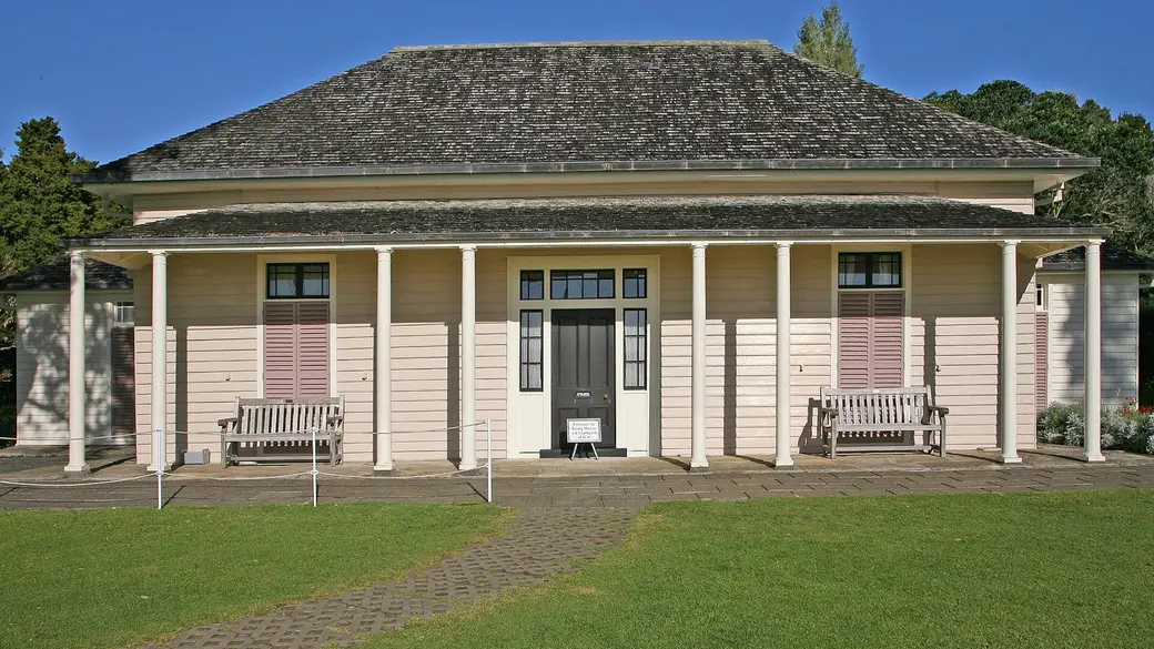
The Treaty House at Waitangi. Photo: W. Bulach via Wikimedia Commons (CC BY-SA 4.0). Spend the morning where the Treaty of Waitangi was signed in 1840, then take the short ferry to Russell for lunch and a wander.
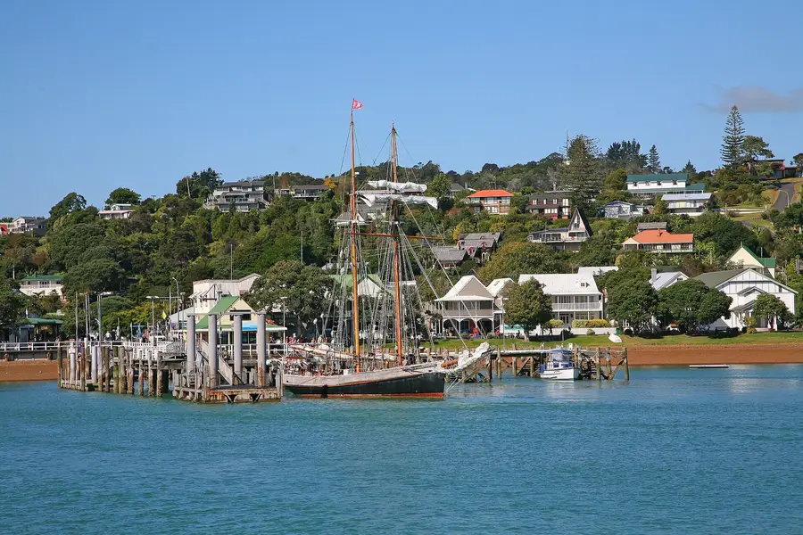
The Bay of Islands is a big, sheltered bay dotted with islands, and it is where much of New Zealand's colonial history began. The Waitangi Treaty Grounds, a short drive or walk north of Paihia, is where Te Tiriti o Waitangi, the Treaty of Waitangi, was signed in 1840. Northland's tourism organisation suggests allowing at least three hours.
Across the water, Russell is a small historic town of wooden buildings and a quiet waterfront. A passenger ferry links it with Paihia in about 15 minutes. Today you do not need the car at all.
If you would rather be on the water, this is also the day for a cruise. Our Bay of Islands guide compares the Hole in the Rock trip and the other options.
How the day runs
- Morning9 am
Waitangi Treaty Grounds: the museums, the Treaty House and the guided tour.
- Midday12.30 pm
Passenger ferry from Paihia to Russell. Lunch on the waterfront.
- Afternoon
Walk around Russell, or join an afternoon cruise from Paihia.
- Evening
Ferry back to Paihia and dinner in town.
Stops and highlights3
Waitangi Treaty Grounds. Two museums, guided tours and cultural performances, with a café on site (Northland NZ). Tickets are valid for two days.
- Time: At least 3 h
- Cost: $78 international adult, $39 New Zealand resident adult, children free
Paihia to Russell passenger ferry. A frequent passenger ferry across the bay between Paihia wharf and Russell (Northland Ferries).
- Time: About 15 min
- Cost: $19.40 adult return
Russell. A small historic town with a pretty waterfront. Good for lunch and a slow walk.
- Cost: Free to wander
Where to stay tonightPaihia
- Same as last night: A second night in Paihia, or move across to Russell if you prefer somewhere quieter.
Tip: Your Waitangi ticket is valid for two days. If the guided tour and museum leave you wanting more, come back for the cultural performance first thing tomorrow.
Practical infoFuel, food, toilets, bookings, costs
- Fuel
- Fill up in Paihia tonight: tomorrow is the longest day.
- Food and coffee
- Café at the Treaty Grounds. Plenty of choice in Paihia and Russell.
- Book ahead
- Waitangi tickets on the day. Book a cruise a day or two ahead in summer.
- Best time of day
- The Treaty Grounds first thing, before tour groups.
- Watch out for
- Waitangi Day (6 February) brings big crowds and events to the Treaty Grounds. Plan around it or embrace it.
- What today costs
- Waitangi $78 international adult; Russell ferry $19.40 adult return (as at November 2026). A cruise is the big optional spend.
Got extra time?
- Car ferry to Russell: drive yourself across on the Opua to Okiato vehicle ferry, $19.80 one way for a car under 6 m (Northland Ferries).
Skip if
Not into history? Spend the morning on a cruise instead, and visit Waitangi on the way out tomorrow morning.
Day 3: Cape Reinga, Te Paki dunes and Ahipara
Paihia→Ahiparavia State Highway 10 and State Highway 1
- DistanceAbout 346 km
- Drive timeAbout 5 h 20 min (estimate)
- OvernightAhipara
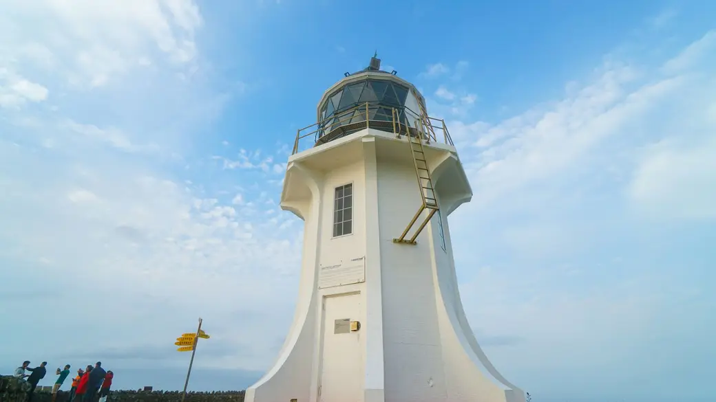
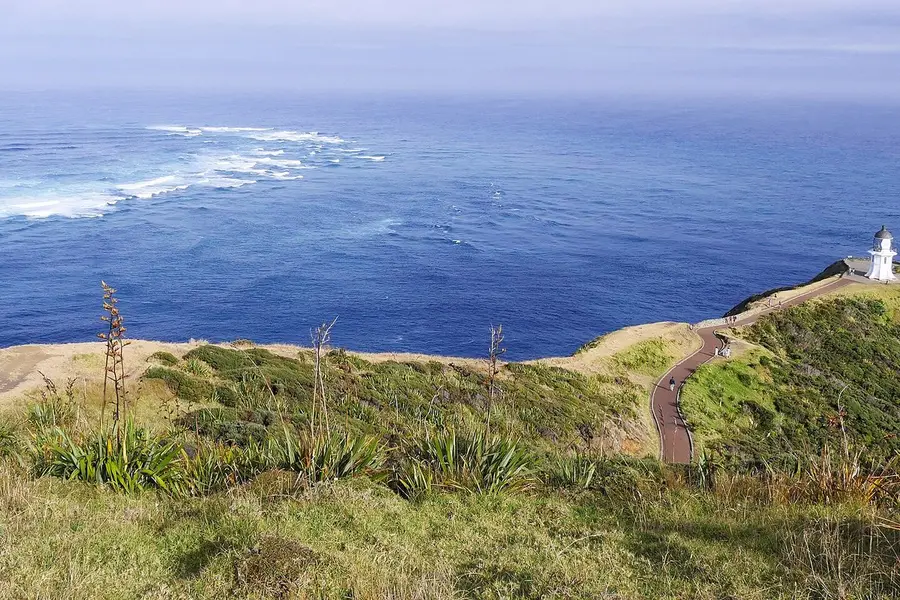
Cape Reinga lighthouse. Photo: Sahar Agranov via Pexels. The big one: fish and chips in Mangōnui, the lighthouse at the top of New Zealand where two oceans meet, giant sand dunes and a night at the end of Ninety Mile Beach.
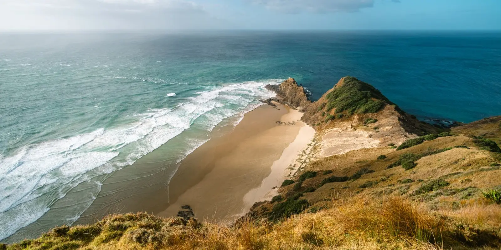
Cape Reinga/Te Rerenga Wairua is near the northernmost point of New Zealand, about 111 km north of Kaitaia (DOC). From the lighthouse you can watch the Tasman Sea and the Pacific Ocean meet in a line of churning waves over the Columbia Bank. DOC describes it as a highly significant place for Māori, with tikanga (cultural protocols) for visitors, which are simple to follow.
This is the longest day of the trip. Our routing estimate from Paihia to the cape via Mangōnui is about 215 km and 3 hours 10 minutes, then about 131 km and 2 hours 10 minutes back down to Ahipara via the Te Paki dunes, all without stops. The roads are sealed, but the last stretch north of Kaitaia has long gaps between services.
Ninety Mile Beach, Te Oneroa-a-Tōhē, runs down the west coast beside you. It is legally a road, but Northland's tourism organisation says it is only suitable for 4WD vehicles and confident off-road drivers, and rental contracts generally do not allow beach driving. Stay on the highway.
How the day runs
- Morning7.30 am
Leave Paihia with a full tank. Drive north to Mangōnui on Doubtless Bay.
- Midday11 am
Early lunch in Mangōnui, then on north through Kaitaia's outskirts to the cape. Arriving after 3 pm misses the midday crowds.
- Afternoon3 pm
Walk to the lighthouse. Then the Te Paki dunes on the way back south.
- Evening6.30 pm
Arrive in Ahipara at the southern end of Ninety Mile Beach, in time for sunset.
Stops and highlights4
Mangōnui. A harbour village on Doubtless Bay, home of the Mangōnui Fish Shop, which Northland's tourism organisation calls world-famous. A good place to break the drive.
Cape Reinga Lighthouse Walk. A short paved walk from the car park to the lighthouse, suitable for children and buggies, with steep drop-offs beside the track. Please do not eat food at the cape (drinking water is fine). No dogs or other pets, and there are no rubbish bins, so take everything with you (DOC).
- Time: About 10 min each way
- Cost: Free
- Parking: Free; car park gates are closed overnight
Te Paki giant sand dunes. Huge golden dunes in the Te Paki Recreation Reserve. Turn off SH1 onto Te Paki Stream Road and drive 3 km to the end. People have been seriously injured sandboarding here and one person has died, so start small, and never board down a dune into the stream where vehicles drive (DOC).
- Time: Allow 1 h
- Cost: Free to walk; sandboard hire is extra
Ahipara and Shipwreck Bay. Ahipara sits at the southern end of Ninety Mile Beach. Te Kōhanga Shipwreck Bay is known for its surf breaks, and its namesake wreck is still visible at low tide (Northland NZ).
- Cost: Free
Where to stay tonightAhipara
- Holiday park: Ahipara TOP 10 Holiday Park has cabins, motels, powered sites and tent areas near Ninety Mile Beach and Shipwreck Bay.
- Camp near the cape: Tapotupotu Campsite, 5 to 10 minutes' drive from the cape on a gravel road, is run by Ngāti Kuri and must be booked (DOC). It breaks the day in two if you would rather see the cape at dawn.
- Freedom camping: Self-contained only, where the council allows it. See our freedom camping guide.
Tip: Bring your lunch for the cape in the car and eat it at Tapotupotu Bay. You respect the tikanga at the lighthouse, and you get a beautiful beach with toilets for your picnic.
Ninety Mile Beach is not a shortcut. Rental contracts generally forbid beach driving, and it is only suitable for 4WD vehicles and confident off-road drivers (Northland NZ, as at November 2026).
Practical infoFuel, food, toilets, bookings, costs
- Fuel
- Fill up in Paihia, and top up in Kaitaia or nearby on the way north. Kaitaia is the supply hub for the Far North (Northland NZ).
- Food and coffee
- Mangōnui for lunch. Do not eat at the cape itself: Tapotupotu Bay is the nearest picnic spot, with toilets (DOC). Kaitaia has supermarkets.
- Toilets and dump stations
- At the cape car park and at Tapotupotu.
- Book ahead
- Ahipara beds, or the Tapotupotu campsite.
- Best time of day
- DOC says the cape is busiest in late December and early January, and every day from 11 am to 3 pm. Aim for late afternoon.
- Phone coverage
- Coverage is patchy in the Far North. Download offline maps in Paihia.
- Watch out for
- The cape is very exposed and DOC warns that strong wind is common, so bring a warm layer. Car park gates close in the evening and open in the morning: check the times on DOC's page before you plan a sunset visit.
- What today costs
- All of today's stops are free. Costs are fuel, lunch and your bed.
Got extra time?
- Cape Reinga by bus: if you would rather not drive, day tours run from Paihia and Kaitaia. Our Bay of Islands guide covers the Paihia option.
Skip if
Skip the dunes if it is late or windy: sand blasts at high speed on a windy day, and the cape is the priority.
Day 4: Ahipara to the Hokianga: ferry, galleries and Opononi
Ahipara→Opononivia Kohukohu and the Hokianga vehicle ferry
- DistanceAbout 104 km
- Drive timeAbout 1 h 50 min, plus the 15 min ferry (estimate)
- OvernightOpononi
A slow, scenic day: country roads to Kohukohu, a 15 minute car ferry across the Hokianga Harbour, lunch in Rāwene and golden sand dunes at Opononi.
The Hokianga Harbour is a long, winding harbour on the west coast, ringed by small settlements. It feels a world away from the busy east coast.
From Ahipara you drive south to Kohukohu, a quiet village of old wooden buildings and galleries, and cross the harbour on the Hokianga vehicle ferry to Rāwene. Our routing estimate from Ahipara to Rāwene, including the ferry, is about 81 km and 1 hour 30 minutes, then about 23 km and 20 minutes on to Opononi.
Today is short by design, after yesterday's big drive. The roads are narrow and winding in places, so take your time.
How the day runs
- Morning9.30 am
Leave Ahipara and drive to Kohukohu. Browse the galleries.
- Midday12 pm
Catch the ferry from the Narrows terminal near Kohukohu, which leaves on the hour, across to Rāwene. Lunch at the Boatshed Cafe.
- Afternoon
Drive on to Opononi and Omapere. Walk on the beach.
- Evening
Sunset over the harbour mouth.
Stops and highlights3
Hokianga vehicle ferry. Runs between the Narrows terminal near Kohukohu and Rāwene, crossing in 15 minutes. Southbound from the Narrows it sails on the hour until a last sailing at 8 pm (from 7.15 am on weekdays). Pay on board by cash, EFTPOS, Visa or Mastercard (Far North District Council).
- Time: 15 min crossing
- Cost: $20 one way for a car under 2,500 kg; $40 for a campervan with a bed over 2,500 kg; $2 per passenger
Rāwene. A small harbourside town. Northland's tourism organisation recommends the Boatshed Cafe for brunch or lunch and the art galleries here and at Kohukohu.
Opononi and Omapere. Two seaside villages near the mouth of the Hokianga Harbour, good for a beach walk and sunset.
- Cost: Free
Where to stay tonightOpononi
- Hotel: Opononi Hotel has rooms, villas and apartments.
- Other options: Holiday parks and motels around Opononi and Omapere. Book ahead in summer.
- Freedom camping: Self-contained only, where the council allows it. See our freedom camping guide.
Tip: The ferry runs to a simple timetable, so check the departure times before you leave Ahipara and you will not wait more than a few minutes.
Practical infoFuel, food, toilets, bookings, costs
- Fuel
- Fill up in Ahipara or Kaitaia before you leave. Services in the Hokianga are limited.
- Food and coffee
- Kohukohu and Rāwene for coffee and lunch, Opononi for dinner.
- Book ahead
- Your Opononi bed. The ferry does not need booking.
- Best time of day
- Mid-morning for the galleries, so you reach Rāwene for lunch.
- Phone coverage
- Coverage is patchy around the Hokianga.
- Watch out for
- Narrow, winding roads. Drive slowly and expect slow vehicles.
- What today costs
- Ferry $20 for a car or $40 for a campervan (as at November 2026), plus $2 per passenger.
Got extra time?
- Harbour cruise: Northland NZ suggests the Ranui history harbour tour from Rāwene if you want longer on the water.
Skip if
In a hurry? Drive straight from Ahipara to Opononi via Kaikohe and skip the ferry, but you miss the best part of the day.
Day 5: Tāne Mahuta, the kauri coast and back to Auckland
Opononi→Aucklandvia State Highway 12, Waipoua Forest and Dargaville
- DistanceAbout 258 km
- Drive timeAbout 3 h 30 min (estimate)
- OvernightAuckland
Meet New Zealand's largest known living kauri tree, drive through ancient forest, and head home via the kauri coast.
South of Opononi, State Highway 12 winds through the Waipoua Forest, one of the last big stands of kauri, the giant native trees that once covered much of Northland. Its most famous resident is Tāne Mahuta, Lord of the Forest, New Zealand's largest known living kauri (DOC).
Before the walk you clean your shoes at a wash station, which helps protect the forest. It takes a minute, and the track itself is short and easy (DOC).
After the forest you drive south through Dargaville and back to Auckland. Our routing estimate is about 85 km and 1 hour 10 minutes from Opononi to Dargaville via Tāne Mahuta, then about 173 km and 2 hours 25 minutes to Auckland, without stops.
How the day runs
- Morning9 am
Drive 18 km to Tāne Mahuta, which opens at 9 am. Walk in while it is quiet.
- Midday
Continue through the forest to Dargaville for lunch.
- Afternoon
The Kauri Museum or a swim at the Kai Iwi Lakes, then the drive to Auckland.
- Evening
Back in Auckland. Return your vehicle tomorrow morning if you can, to avoid the rush.
Stops and highlights3
Tāne Mahuta Walk. A short, easy walk suitable for buggies and children, signposted from SH12. It is open 9 am to 4 pm daily, and the gate is locked outside those hours. Toilets and a picnic area are 25 m back from the car park, across the road. Clean your shoes at the wash station (DOC).
- Time: 5 min one way
- Cost: Free
- Parking: Roadside car park on SH12
Kai Iwi Lakes. Dune lakes north of Dargaville, which Northland's tourism organisation calls crystal-clear. A lovely swim stop on a hot day.
- Time: About 1 h detour from Dargaville
The Kauri Museum. South of Dargaville, telling the story of the kauri trees and the industries that relied on them (Northland NZ).
- Time: Allow 1 to 2 h
Where to stay tonightAuckland
- Kai Iwi Lakes: Want one more night? Kai Iwi Lakes Campground has Pine Beach sites at $25 powered or $20 non-powered per adult, and Promenade Point at $15 per adult, plus a $10 admin fee.
- Auckland: A hotel near the airport or your vehicle drop-off for an easy morning.
Tip: Get to Tāne Mahuta right at 9 am. The walk is so short that tour groups move through quickly, and you may have the tree almost to yourself.
Practical infoFuel, food, toilets, bookings, costs
- Fuel
- Dargaville is the main fuel stop on this stretch.
- Food and coffee
- Opononi for breakfast, Dargaville for lunch.
- Toilets and dump stations
- At Tāne Mahuta, 25 m back from the car park (DOC).
- Book ahead
- Your Auckland bed and vehicle return.
- Best time of day
- Tāne Mahuta at 9 am opening, before the tour buses.
- Watch out for
- SH12 through Waipoua Forest is narrow and winding. Drive slowly, especially after dark.
- What today costs
- Free stops today, unless you visit The Kauri Museum.
Got extra time?
- Ripiro Beach: near Dargaville, the longest drivable beach in New Zealand according to Northland NZ, though rental vehicles should stay off it.
Skip if
If you are returning a vehicle in Auckland this afternoon, skip the Kai Iwi Lakes detour.
Trip complete
That's the loop. You legend.
5 days and about 970 km of driving, back where you started in Auckland.
Full route in Google Maps (opens in a new tab)Back to the top of the itinerary
Drive times and distances
These are routing estimates without stops, rounded. Add 20 to 30 per cent for stops, campervans and roadworks.
| Day | Leg | Distance | Drive (estimate) |
|---|---|---|---|
| 1 | Auckland to Whangārei via Whangārei Falls | About 176 km | About 2 h 40 min |
| 1 | Whangārei to Paihia | About 70 km | About 1 h |
| 3 | Paihia to Cape Reinga via Mangōnui | About 215 km | About 3 h 10 min |
| 3 | Cape Reinga to Ahipara via Te Paki dunes | About 131 km | About 2 h 10 min |
| 4 | Ahipara to Rāwene, including the ferry | About 81 km | About 1 h 30 min |
| 4 | Rāwene to Opononi | About 23 km | About 20 min |
| 5 | Opononi to Dargaville via Tāne Mahuta | About 85 km | About 1 h 10 min |
| 5 | Dargaville to Auckland | About 173 km | About 2 h 25 min |
| Whole loop | About 970 km | About 13 h 40 min |
For comparison, driving straight from Auckland to Paihia is about 225 km and 3 hours 10 minutes by our routing estimate.
Cape Reinga: what to know before you go
Cape Reinga/Te Rerenga Wairua is the emotional high point of the trip, and a few things make the visit go smoothly:
- It is sacred. DOC asks visitors not to eat food at the cape (drinking water is fine). Take your picnic to Tapotupotu Bay, 5 to 10 minutes away on a gravel road.
- Timing matters. It is busiest from 11 am to 3 pm and in late December and early January (DOC). Late afternoon is calmer and the light is softer.
- It is windy. The cape is very exposed, and the weather changes fast.
- No pets and no bins. Leave dogs at home and take all rubbish with you.
- No camping at the cape. The nearest campsite is Tapotupotu, run by Ngāti Kuri, and it must be booked.
- Stay off Ninety Mile Beach in a rental. It is legally a road, but Northland NZ says rental contracts generally do not allow beach driving.
Insider tip: if you want the cape without the long round trip, book a night at Tapotupotu Campsite. You can visit the lighthouse in the quiet early morning and still be in Ahipara by lunchtime.
Where to stay
| Night | Base | Suggestions |
|---|---|---|
| 1 and 2 | Paihia | Motels, backpackers and holiday parks near the waterfront |
| 3 | Ahipara | Ahipara TOP 10 Holiday Park, or Tapotupotu Campsite near the cape |
| 4 | Opononi | Opononi Hotel, or motels and holiday parks in Opononi and Omapere |
| 5 | Auckland, or Kai Iwi Lakes | Kai Iwi Lakes Campground for one more night by the water |
Summer weekends and the Christmas holidays fill Northland quickly, so book as soon as your dates are firm. Freedom camping is self-contained only, in places the council allows; our freedom camping rules explain the details.
Costs on this route
We do not invent a daily total. These are the verified prices on this route as at November 2026, per adult unless stated:
| Item | Cost |
|---|---|
| Whangārei Falls, Cape Reinga, Te Paki dunes, Tāne Mahuta | Free |
| Waitangi Treaty Grounds (international adult) | $78 |
| Paihia to Russell passenger ferry (return) | $19.40 |
| Opua to Okiato car ferry (car under 6 m, one way) | $19.80 |
| Hokianga vehicle ferry, car (one way) | $20 |
| Hokianga vehicle ferry, campervan over 2,500 kg (one way) | $40 |
| Kai Iwi Lakes, Pine Beach powered site | $25 per adult, plus $10 admin fee |
On top of these, budget for your vehicle, fuel for about 970 km, beds and food. Our car rental guide explains what to check before you sign, including beach-driving clauses.
Variations
- Seven days: follow Northland NZ’s suggestion and add a night at Mangōnui on Doubtless Bay and a night at Kai Iwi Lakes.
- Skip the cape: short of time? Drive from Paihia across to the Hokianga via Kerikeri and Kaikohe, and turn this into a four-day loop.
- Join the North Island route: continue south from Auckland on our 10-day North Island road trip.
FAQ
How many days do you need for the Twin Coast Discovery route?
Can I drive on Ninety Mile Beach in a rental car?
Is Cape Reinga worth the drive?
Do I need to book the Hokianga ferry?
When is the best time for a Northland road trip?
Sources
Last checked 11 November 2026
- The Twin Coast Discovery Highway · Northland Inc (Northland NZ)
- Top of the North suggested itinerary · Northland Inc (Northland NZ)
- Ōtuihau Whangārei Falls · Whangārei District Council
- Whangārei Falls platforms project · Whangārei District Council
- Hours and admission · Hundertwasser Art Centre
- Waitangi Treaty Grounds: visit and tickets · Waitangi Treaty Grounds
- Paihia to Russell passenger ferry and Opua to Okiato vehicle ferry · Northland Ferries
See more sources (9)See fewer
- Cape Reinga/Te Rerenga Wairua Lighthouse Walk · Department of Conservation
- Te Paki sand dunes · Department of Conservation
- Tapotupotu conservation campsite · Department of Conservation
- Ahipara TOP 10 Holiday Park · Ahipara TOP 10 Holiday Park
- Hokianga vehicle ferry · Far North District Council
- Opononi Hotel · Opononi Hotel
- Tāne Mahuta Walk · Department of Conservation
- Kai Iwi Lakes Campground · Kai Iwi Camp
- Route distances and drive times (OpenStreetMap routing, no stops) · Project OSRM